


UWCHLAN TWP PCT 05, Chester County, Pennsylvania
About
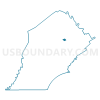
Outline

Summary
| Unique Area Identifier | 658485 |
| Name | UWCHLAN TWP PCT 05 |
| County | Chester County |
| State | Pennsylvania |
| Area (square miles) | 0.75 |
| Land Area (square miles) | 0.74 |
| Water Area (square miles) | 0.01 |
| % of Land Area | 98.94 |
| % of Water Area | 1.06 |
| Latitude of the Internal Point | 40.05437470 |
| Longtitude of the Internal Point | -75.62659020 |
Maps

Graphs
Select a template below for downloading or customizing gragh for UWCHLAN TWP PCT 05, Chester County, Pennsylvania


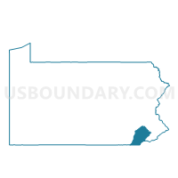
Neighbors
Neighoring Voting District (by Name) Neighboring Voting District on the Map
- CHARLESTOWN TWP Voting District, Chester County, PA
- UWCHLAN TWP PCT 01, Chester County, PA
- UWCHLAN TWP PCT 03, Chester County, PA
- UWCHLAN TWP PCT 04, Chester County, PA
- UWCHLAN TWP PCT 09, Chester County, PA
- WEST PIKELAND TWP Voting District, Chester County, PA
- WEST WHITELAND TWP PCT 06, Chester County, PA
Top 10 Neighboring County Subdivision (by Population) Neighboring County Subdivision on the Map
- West Whiteland township, Chester County, PA (18,274)
- Uwchlan township, Chester County, PA (18,088)
- Charlestown township, Chester County, PA (5,671)
- West Pikeland township, Chester County, PA (4,024)
Top 10 Neighboring Place (by Population) Neighboring Place on the Map
Top 10 Neighboring Unified School District (by Population) Neighboring Unified School District on the Map
- West Chester Area School District, PA (108,433)
- Downingtown Area School District, PA (68,499)
- Great Valley School District, PA (29,816)
Top 10 Neighboring State Legislative District Lower Chamber (by Population) Neighboring State Legislative District Lower Chamber on the Map
Top 10 Neighboring State Legislative District Upper Chamber (by Population) Neighboring State Legislative District Upper Chamber on the Map
Top 10 Neighboring 111th Congressional District (by Population) Neighboring 111th Congressional District on the Map
Top 10 Neighboring Census Tract (by Population) Neighboring Census Tract on the Map
- Census Tract 3022.02, Chester County, PA (6,899)
- Census Tract 3020, Chester County, PA (5,671)
- Census Tract 3044.04, Chester County, PA (4,859)
- Census Tract 3019, Chester County, PA (4,024)
- Census Tract 3044.03, Chester County, PA (3,840)